Managing climate disasters from space
Summer 2023 is going into the history books as one of the hottest summers ever.
According to Copernicus — the EU climate and weather service — July 2023 was the hottest month ever on record. Extreme climate phenomena hit various regions of Europe, challenging civil protection systems and the efforts of fire brigades.
In Sicily, extremely high temperatures were recorded — reaching 43.3°C in the island's inland regions, which dramatically increased the danger of fires. The mountains surrounding the city of Palermo, the island's capital, were destroyed by mass fires, threatening the population, blocking the airport and torching the Bellolampo dump on the outskirts of the city, triggering dioxin alerts.
Greece is facing another wave of wildfires. Recently, around 77,000 hectares of land have burned, putting hundreds of firefighters under strenuous conditions. In addition, 21 people died due to the blaze. Now that extreme events are becoming more frequent and long-term solutions seem unlikely to be reached, innovative and resilient measures must be implemented in order to improve emergency response by civic forces.
Help from space
One avenue could be providing more assistance from space. But what is the key to successful implementation of useful tools that could help us from space? The EU Space Programme is trying a number of innovative approaches to help first responders, citizens and governments.
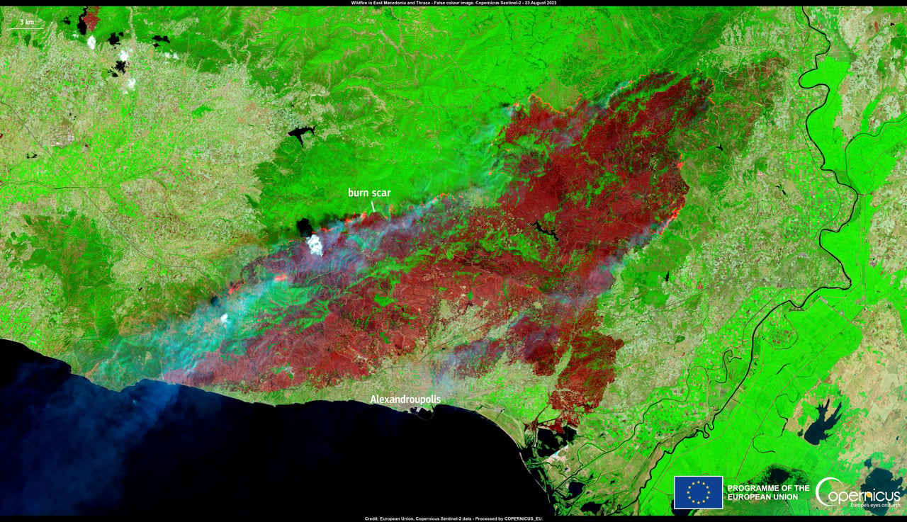 Copernicus monitoring of wildfires in Greece this August.
The EU Space Programme is a complex body consisting of a number of components: Galileo, EGNOS, the before-mentioned Copernicus, GOVSATCOM, IRIS² and Space Traffic Management (which we covered in a previous article on so-called space junk). When it comes to disaster management, each component is crucial, as it provides a unique contribution in the mitigation chain.
For example, while aerial firefighting assets and first responders rely on the precise positioning provided by the European Geostationary Navigation Overlay Service (EGNOS) and Galileo — the EU´s Global Navigation Satellite System (GNSS) — to guide them safely through smoke, fog and flames, Copernicus Emergency Management Service (CEMS) Rapid Mapping module provides decision-makers with critical geospatial data with accurate information about the affected areas allowing the continuous assessment of the damage.
Broadcasting warnings without cell service
A new Galileo service will soon enhance the responsiveness of emergencies.
The Directorate General for Defence Industry and Space (DEFIS) has included a regulation for the EU Space Programme, which introduces the Emergency Warning Satellite Service (EWS) in the Galileo service portfolio. The design and implementation is led by EUSPA.
The EWS will support and complement the Public Warning System by taking advantage of the Galileo's global coverage and its possibility to reach population at a large scale, in a timely manner. The signal is resilient to ground destruction and independent of terrestrial mobile networks.
EWS is a major differentiator for Galileo, compared to other global positioning systems, with a high strategic value. Up to 450 million EU citizens are expected to directly benefit of the service without the need for specific equipment.
This upcoming EWS alert service is designed to be received directly on any device capable of processing Galileo signals: smartphones, car navigation, fixed receivers on the roofs of buildings for display on public billboards, and more devices that are connected to the European global position system.
The EWSS will benefit from the Galileo Signal in Space (E1 and E5b) to disseminate an authenticated (via OSNMA) alert message, including guidance to react and relevant geo-location information encoded alerting only the affected population.
The service is not based on a mobile network, and can reach any smartphone with a global positioning chip in a specific target area with satellite coverage. This feature enables the service to reach people in rural regions with poor mobile signal and can even be available during a disaster that affects the ground infrastructure.
While Member States and their Civil Protection Administration and services remain competent in deciding to trigger an alert, Galileo EWSS will enable a satellite broadcasting channel to reach a target area and its population in a timely and reliable manner.
EWSS will be free of charge, with global coverage, versatile, resilient, fast, secure, complementary and independent to other existing public warning systems such as mobile networks, TV, radio, sirens, internet or social networks.
As of March 2022, it became mandatory for all mobile phones sold in the European Single Market to be Galileo-enabled. This means that if someone places an emergency call, the emergency responders will receive their location information with an accuracy down to just a few metres.
The improved accuracy has a major impact in terms of response times, ultimately allowing for quicker intervention in emergency situations where every second counts — resulting in more lives being saved. The ability for 112 to communicate a caller's location automatically to emergency services is possible thanks to the Advanced Mobile Location (AML) system which is already available in most EU Countries.
EWSS is not Galileo's only emergency service. The Galileo Search And Rescue Service (SAR) launched in December 2016 contributes to live-saving efforts by providing accurate, timely, and reliable 406Mhz beacon distress signals to SAR authorities .
Recently, a sailor in a solo round-the-world yacht race was saved thanks to the positioning given to rescuers by his emergency beacon after waves destroyed his vessel. Likewise, in case medical assistance is needed, helicopter operators and pilots can rely on Galileo's European Geostationary Navigation Overlay Service (EGNOS) to land safely, especially when visibility is reduced due to fire smoke or fog.
Additionally, services like the Galileo High Accuracy and Open Service Navigation Message Authentication (OSNMA) services ensure that drones deliver accurate mapping as well as assistance to inaccessible areas due to natural disasters such as earthquakes.
Space and the Green Deal
The development of the EU Space Programme is in line with European policies such as the EU Green Deal. The technology implemented looks to the present and the future in the direction of sustainable and efficient emergency management that can trigger decision-making and problem-solving in both emergencies and in the long term.
EUSPA Executive Director, Rodrigo da Costa says that "Galileo, EGNOS, Copernicus, are powerful tools individually, but an exponential achievement is reached when used in synergy. Soon, the addition of the European Union Governmental Satellite Communications (GOVSATCOM) and IRIS² Satellite Constellation, will add an extra layer of efficiency in the management of disasters by providing secured and uninterrupted satellite communications to EU Member States."
"The Emergency Management and Disaster Response sector is one of the key sectors where this synergy is saving lives", da Costa concludes.
Satellite synergies
Copernicus, mentioned earlier, is another fundamental tool for observing emergency phenomena, and provides benefits for prevention and emergency purposes.
More precisely, the Copernicus Emergency Management Service (Copernicus EMS) uses data from a range of satellites and ground-based sensors to provide information about the location, extent, and behaviour of fires and floods. This information helps emergency responders make informed decisions regarding where to direct resources and in the case of fires, how to contain the blaze. Copernicus is provided free of charge to all users.
Copernicus doesn't only monitor blazes, but also keeps an eye on the air quality. The Copernicus Atmosphere Monitoring Service (CAMS) can monitor emissions which can, in turn, be used in smoke forecasts.
These forecasts are used in air quality apps to help people limit their exposure to pollution, and by policymakers and local authorities to manage the impact of fires. Space tech could thus drastically change how we manage environmental emergencies. But in order for these technologies to show their real potential, they must fit within a techno-ecological system, working in synergy with each other.
"Synergy between GNSS and Earth Observation are particularly beneficial to drone operations, which emergency response teams use for everything from inspecting flooded areas to post-earthquake search and rescue operations and monitoring remote wildfires," EUSPA's SAR/Galileo Service Provision Manager, Pol Novell tells EUobserver.
Firefighting teams are replacing traditional ground-based systems supported by manned aircraft with more cost-effective drones. Novell affirms that "Equipped with a wide-range of sensors for capturing Earth Observation data and navigated using GNSS positioning, advanced drones can now provide firefighters with another layer of information — and protection."
The future of emergency management is therefore already here. With the support of local and rural communities, the vast experience of member countries' civil protection and fire brigades, and the use of increasingly advanced technologies, it is possible to develop a holistic, sustainable and efficient emergency management system.
Disclaimer
This article is sponsored by a third party. All opinions in this article reflect the views of the author and not of EUobserver.Author Bio
This article was commissioned by the European Union Agency for the Space Programme (EUSPA), and produced by EUobserver as partner content.
Tags
Author Bio
This article was commissioned by the European Union Agency for the Space Programme (EUSPA), and produced by EUobserver as partner content.